GEO BON- Microsoft: EBV’s on the Cloud AI for the National Belize Marine Habitat Map

Background
Click here for Project Dataset and Report
Since late 2020, Belize’s Coastal Zone Management Authority & Institute (CZMAI), supported by GRH Consulting Ltd., has been implementing the “AI for the Belize National Marine Habitat Map” project, which is funded by Microsoft, in the framework of a solicitation from the Group on Earth Observations’ Biodiversity Observation Network (GEO BON). For this project, Microsoft Azure was used for machine learning-based mapping of the Essential Biodiversity Variable (EBV) of ecosystem extent and fragmentation. Via this work, Belize’s 1997 30m Landsat-based National Marine Habitat Map was updated, using a combination of Microsoft Azure’s cloud computing power in conjunction with field surveys, 3m PlanetScope imagery, supplementary 10m Sentinel-2 imagery, and Machine Learning techniques. As such, the data will be used to provide updated estimates of the status of Belize’s major coastal and marine ecosystems. In addition to helping inform Belize’s Nationally Determined Contribution (NDC) to the Paris Agreement, the data will now be used to support the country’s implementation of Sustainable Development Goal 14 and will be integrated into the revision of the National Integrated Coastal Zone Management Plan. Additionally, these ecosystems are recognized for their blue carbon focus and potential to contribute to Belize’s climate change mitigation efforts.
The project’s overall objective is the updating of the National Marine Habitat Map (NMHM) using the significant cloud computing resources provided by Microsoft, with the specific objectives as follows:
- updating of the NMHM using more recent satellite data of Belize’s marine areas
- increasing the spatial resolution of the NMHM using higher spatial resolution imagery, and
- making use of extensive cloud computing resources from Microsoft Azure for the update.
Data Products and Derived Indicators:
Table 1: Essential Biodiversity Variables (EBVs) to be addressed, based on GEO BON’s EBV classes and candidates.
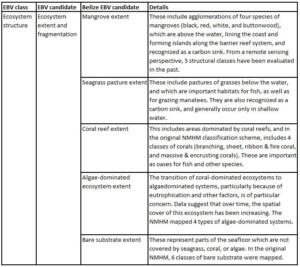
It should be noted that the spatial extent of seagrass and coral reef ecosystems respectively would be the priority EBV candidates for this study, as priority ecosystems for conservation in Belize. While algae-dominated systems and bare substrate are not conservation priorities, it is expected that the degradation or outright removal of seagrasses and corals will result in shifts to these ecosystems, so mapping the extents of those are crucial to understanding fragmentation of the priority ecosystems.
Capacity Building Initiatives
In late 2020, the project held a stakeholder workshop to launch the project in Belize and gather information for integration and collaboration. Additionally, as part of the GEO BON Project, the CZMAI (Coastal Zone Management Authority &Institute) team, leading the project, conducted a ground-truthing activity within the Belize Central Region for the key habitat classes which included coral, seagrass, and mangrove. The team visited several locations that were used to contribute to the validation and accuracy assessment of the project’s outputs (Figure 1).
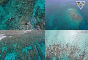
Figure 1. Upper left: CZMAI team at the field sites, collecting underwater photography and videos of the corals. Upper right, lower left & right: High-resolution drone imagery of a coral patch.
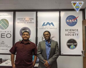
Figure 2: Showing CZMAI GIS Technician along with Dr. Emil Cherrington at Huntsville Alabama
As part of the capacity-building initiatives, CZMAI’s GIS technician, Delwin Guevara, participated in a short technical exchange in Huntsville, Alabama from July 26-31, 2021(Figure 2). The exchange specifically focused on (1) the implementation of an instance of ESRI ArcGIS on the cloud, (2) the structure and capabilities of the Microsoft Azure system, and (3) the methods and considerations for conducting supervised image classification using high-resolution satellite imagery. During the technical exchange, the CZMAI team along with Dr. Emil Cherrington got an opportunity to highlight the exchange and to discuss the project through a virtual interview on Belize’s Open Your Eyes (Figure 3).

Figure 3: CZMAI and GRH’s appearance on Channel 5’s Open Your Eyes (OYE)
Focusing on the major marine habitat types of Belize’s territorial sea, over a hundred individual supervised image classifications based on 10m Copernicus Sentinel-2 data were generated. The final phase of this study included validation of the project outputs via formal accuracy assessment, and expert evaluation held via a workshop in November 2021 (Figure 4).
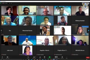
Figure 4. Government representatives and industry stakeholders during validation session held in November 2021
Related to the policy relevance of GEO BON and its goals, the Coastal Zone Management Authority & Institute – the project’s implementing agency – is also integrating the data into the revision of Belize’s Integrated Coastal Zone Management Plan (2016).
![]()
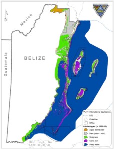
Figure 5. The final output of the supervised classification of the Sentinel-2 data with 6 spectral classes (algae-, bare substrate-, seagrass- and coral-dominated habitats, turbid water, and deep water).
National Marine Habitat Map Dataset
Click here for Project Dataset and Report
Dataset Summary
While the original NMHM (1997) identified nine-teen (19) total benthic habitat types, for the purposes of this project, one means of addressing the inevitable errors that were encountered was aggregating up to a simpler benthic classification, specifically the four (4) types:
- Coral-dominated,
- Algae-dominated,
- Bare substrate-dominated and
- Seagrass-dominated.
Description
The dataset contains the four benthic classifications and can be found in two outputs, a 10m and a 30m resolution. The geographic domain includes a 20,538 km2 area including all of Belize’s territorial sea, and an area extending a little into Belize’s Exclusive Economic Zone (EEZ), where the tri-national marine borders of Belize, Guatemala, and Honduras intersect. Data from the Copernicus Sentinel-2 were used, because of the 10m spatial resolution of its spectral bands in the visible part of the electromagnetic spectrum. Level 1C Top-of-Atmosphere (TOA) reflectance data from Sentinel-2 are available from the Copernicus Open Access Hub. The Sentinel-2 data were acquired from and pre-processed with the Google Earth Engine (GEE) cloud processing platform.
To improve the spatial resolution of the NMHM, higher spatial resolution was also evaluated Planet Scope data (4.77m) were also evaluated, and acquired from Planet. The project focused the mapping on the Sentinel-2 data because the publicly available Planet imagery only has four bands in the visible and near-infrared (VNIR) part of the electromagnetic spectrum; the Sentinel-2 data possess thirteen (13) spectral bands. A total of 3,918 training samples were used to train the supervised classifications.
In the Azure VM, in the ArcGIS Desktop environment, supervised classifications in the form of Maximum Likelihood Classification (MLC), Random Trees, and Support Vector Machines were run, in addition to ISODATA unsupervised classifications. The supervised classification runs were limited to training datasets C2 and H. To facilitate testing and comparison, outside of the Azure virtual environment, prior to running the classifications on the Azure VM, some 90 supervised classification runs were prototyped using GEE. In addition to the supervised classifiers available in ArcGIS on Azure, in GEE, the following classifiers were tested with nine (9) indicated versions of the training data:(i) Classification and Regression Trees (CART), (ii) Naïve Bayes, (iii) Random Forest (with 5 different iterations based on the number of ‘trees’) & (iv) Support Vector Machines (SVM). The report can be found with the accompanying datasets or you can contact director@coastalzonebelize.org or gismanager@coastalzonebelize.org
Credits
Belize Coastal Zone Management Authority and Institute & GRH Consulting, 2021, AI for the Belize National Marine Habitat Map.
The Belize Coastal Zone Management Authority and Institute (CZMAI) will be cited as “Belize Coastal Zone Management Authority and Institute” whenever its data are used in publications and reports are produced.
The GRH Consulting will be known as “GRH Consulting” whenever its data are used in publications and reports are produced.
The collection of this data was funded by Microsoft, in the framework of a solicitation from the Group on Earth Observations’ Biodiversity Observation Network (GEO BON).