In 2015, Belize under the leadership of the Ministry of Forestry, Fisheries and Sustainable Development (MFFSD) with fiduciary management assistance from the Protected Areas Conservation Trust (PACT) as the National Implementing Entity (NIE) and the World Bank as Multilateral Implementing Entity (MIE), signed on to implement the Marine Conservation and Climate Change Adaptation Project (MCCAP) in the coastal areas of Belize. MCCAP is a five-year project designed to implement priority ecosystem-based marine conservation and climate adaptation measures to strengthen the climate resilience of the Belize Barrier Reef System and its productive marine resources. The MCCAP project has 4 components: 1) Improving the protection regime of marine and coastal ecosystems; 2) Promotion of viable alternative livelihoods for affected users of the reef in the areas impacted by project activities; 3) Raising awareness and building capacity; and 4) Project Management, Monitoring, and Assessment.
Under this project the CZMAI has received funding to undertake water quality monitoring activities to monitor the successful implementation of the National Integrated Coastal Zone Management (ICZM) which is included as an activity under Component 1 of the MCCAP Project; Improving the protection regime of marine and coastal ecosystems. Under component 1, CZMAI will conduct a study of the Belize River Watershed (BRW). This study will be done by using YSI EXO 2 Sondes. The sondes will measure environmental parameters along the Belize River. The parameters that sonde will be measured include Conductivity, Turbidity, Temperature, pH/ORP (Oxidation/Reduction Potential), Chlorophyll-a, Dissolved Oxygen, precipitation, and flow. Furthermore, the first sample site was chosen near specific land used activities such as Agriculture land. This is very important in order to get a clear idea of the changes in water quality resulting from the agriculture activity in that part of the river. Next, the second sample site is midway between the first and third sample sites. Finally, the third sample site is at the mouth of the Belize River mouth area. The River mouth area test is very crucial because it will capture the outflow from the river. The YSI EXO 2 Sondes device will collect information on an hourly basis every day for one year. The main purpose of the information will be used to study seasonal changes as well as changes that occur as a result of extreme weather events such as tropical cyclones, flooding, drought, etc.
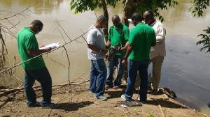
On 21 October 2016, three (3) Sondes were assembled and placed at different locations along the Belize River.
In closing all data collected, will be modeled and use in coastal/marine condition. CZMAI will be in a better position to provide information, and ensure improvement in coastal/marine resource management. The CZMAI utilized the ecosystem based approach to coastal resource management to inform the creation of the National ICZM Plan. This approach focuses on sustainably managing the resource base for all coastal/marine resource use through planning and management interventions that reduce the additional stress of human activities on the environment. Since the ecosystem based approach depends on the sustainability of the resource base (i.e. mangroves, seagrass, and corals) in order for the plan to be a success it depends on the health of the coastal/marine environment. Thus, long term water quality monitoring is necessary in order to detect changes in the coastal/marine environment and address them in an attempt to accomplish the goal of the National ICZM Plan.